By: David Intersimone “David I”
(Created using Google Gemini Notebook based on 90 curated sources – sources listed at the end of this document)
1. Catastrophic Wildfire Threat & Mitigation
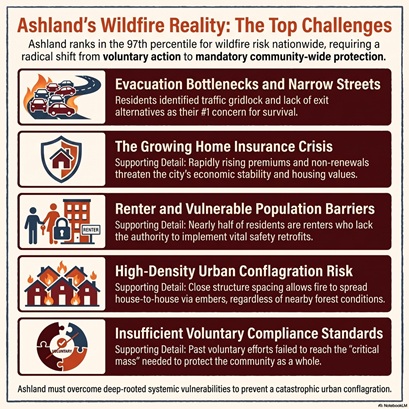
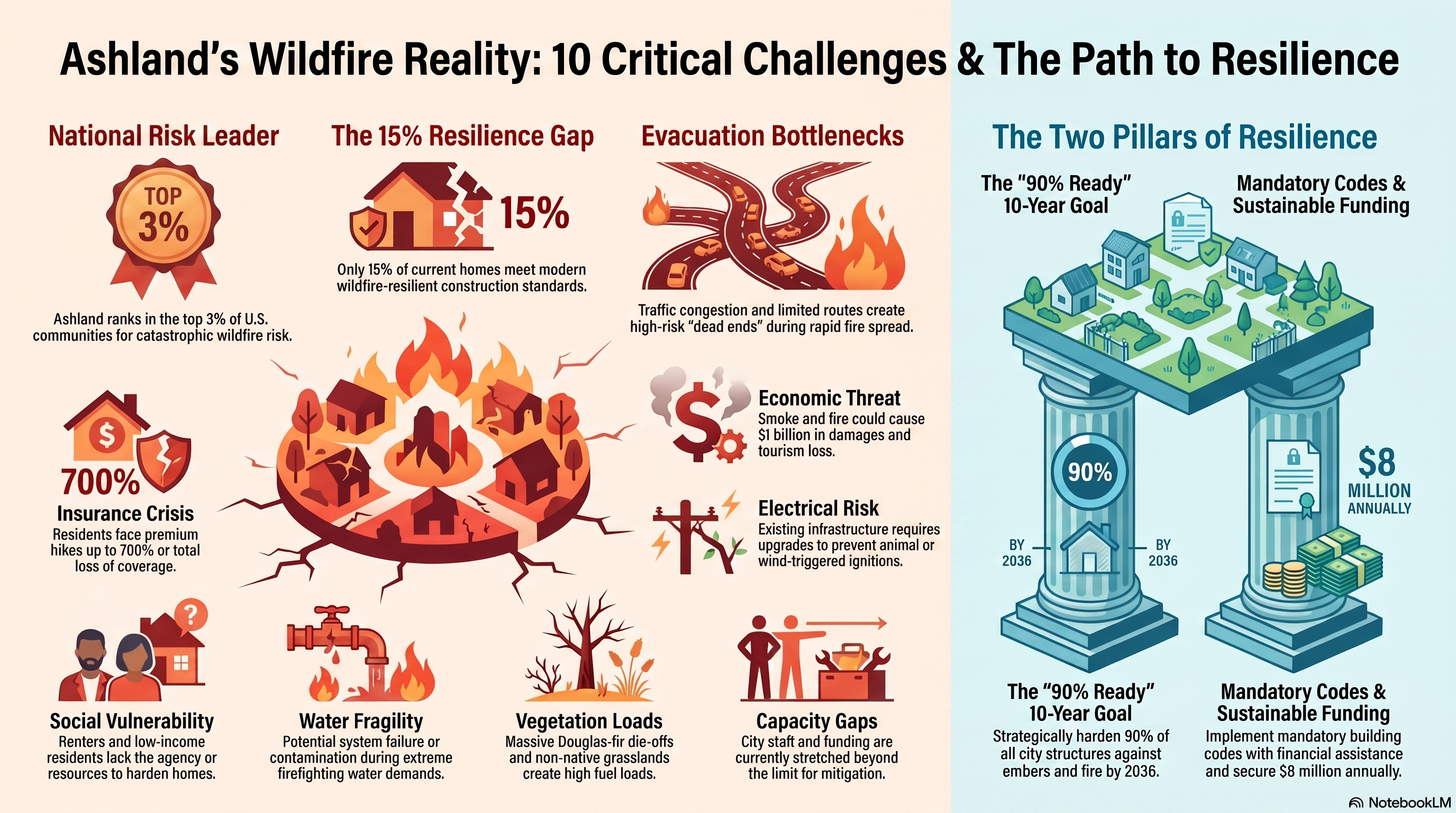
Ashland is ranked in the 97th percentile nationally for wildfire risk due to its climate, fuel loads, and dense urban environment. The city’s 2025 Community Wildfire Protection Plan (CWPP) establishes an ambitious goal to make 90% of local structures wildfire-resistant within the next ten years. Achieving this will require a massive paradigm shift from voluntary to mandatory risk reduction, including strict defensible space enforcement and home hardening codes to prevent an urban conflagration.
2. The Property Insurance Crisis
Rising climate-related disaster costs have created an insurance crisis, leading to skyrocketing premiums and dropped coverage across Southern Oregon. Some Ashland residents have experienced premium increases of up to 600% or 700%. This crisis threatens housing affordability, makes it difficult to fund new affordable housing developments, and leaves uninsured renters at a high risk of permanent displacement if a disaster strikes.
3. Housing Affordability and Preservation
Ashland faces a severe housing crisis, with 41% of households considered cost-burdened by housing expenses. To protect its naturally occurring affordable housing, the city is exploring new zoning to preserve manufactured home parks from being sold and redeveloped. Local leaders also emphasize the need for denser housing and community land trusts to ensure the local workforce can afford to live in the city.
4. City Budget Constraints and Financial Sustainability
The city is navigating structural financial challenges and shrinking revenues relative to rising operational costs. Financial forecasts indicate that without careful planning and efficiencies, the city’s General Fund could fall below its minimum policy balance by the 2029-2030 fiscal year. Competing needs are squeezing departmental budgets, with public safety consuming a massive portion of the general fund, leaving less for parks, recreation, and facility maintenance.
5. Economic Diversification and Workforce Shortages
Ashland’s economy relies heavily on the Oregon Shakespeare Festival (OSF) and tourism, both of which are highly vulnerable to disruptions from wildfire smoke. Compounding this is a shrinking workforce pipeline, as roughly half of Ashland’s population not in the workforce is over the age of 65. The city aims to revitalize its economy by attracting businesses that offer year-round, living-wage jobs in sectors like healthcare and technology.
6. School District Financial Crises and Consolidations
The Ashland School District is navigating significant financial challenges and shifting enrollment trends. To achieve long-term sustainability, the district has formed a Transformation Steering Committee to evaluate potential school consolidations, mergers, facility re-purposing, and grade-level reconfigurations.
7. Evacuation Bottlenecks and Emergency Readiness
Due to Ashland’s narrow streets, steep terrain, and limited access routes, a full city evacuation could take up to four hours under ideal conditions. Residents cite traffic bottlenecks and blocked routes as their top wildfire concern. In response, the city is updating evacuation time studies, coordinating mass evacuation drills, and identifying open spaces as temporary refuge areas for those unable to escape.
8. Climate Change and Forest/Watershed Health
Severe drought and extreme heat have severely impacted local ecosystems, leading to a massive die-off of Douglas-fir trees in the lower Ashland Watershed. This dead vegetation drastically increases the fire danger to the community, trails, and the municipal drinking water supply. The city is actively logging dead trees and shifting its forest management strategy toward climate adaptation to maintain water quality and ecological integrity.
9. Homelessness and Supporting Vulnerable Populations
Managing and supporting the unhoused population remains a complex challenge, as transient encampments in open spaces pose a high risk for accidental wildfire ignitions. The city must balance enforcement of camping regulations with the legal requirement to provide designated sleeping areas, while also protecting socially vulnerable populations who lack the resources to prepare for or recover from disasters.
10. Aging Infrastructure and Facility Relocations
Ashland must address a serious backlog of deferred maintenance across city-owned buildings and utilities. The most critical infrastructure project is the relocation of the city’s aging Water Treatment Plant, which currently sits in a canyon highly vulnerable to floods, landslides, and wildfires. Moving this facility is essential to ensuring a safe and reliable drinking water supply during future emergencies.
Other Concerns
Ashland Community Hospital and Healthcare Access
The sources explicitly confirm the discontinuation of inpatient services as of May 22, 2026. They also confirm that Asante Corporation breached its contract by failing to maintain Ashland Community Hospital as a general hospital through mid-July. The impact of this transition on the city is substantial and is considered a major tipping point for the community:
- Medical Care Access and Travel: Residents report that they will now have to travel much longer to Medford to receive medical care, drastically reducing the time they have with their doctors and removing a facility that many considered an “extension of home”.
- Demographic Flight: During the city’s strategic planning outreach, community members cited healthcare access as a top priority and expressed deep concern that the lack of a hospital will drive older residents and people with chronic health conditions to leave Ashland.
- Financial Impact on the City: If the hospital ceases operations entirely, the city faces a massive structural revenue loss, as the hospital historically paid $835,000 a year in city utility bills.
- Community Mobilization and the $4 Million Penalty: Due to the contract breach, Asante was forced to pay the city a $4 million penalty. In response, a grassroots coalition called Save Our Ashland Community Hospital (SOACH) has formed, gathering over 2,000 signatures to demand the city place the $4 million in a lock box reserve fund for the next three years to plan for future healthcare infrastructure or a potential healthcare district.
Lack of Federal and State Funding
The sources heavily discuss the lack of state and federal funding across multiple sectors, presenting a recurring challenge for Ashland’s future sustainability:
- Healthcare Funding: City Councilor Dylan Bloom explicitly pointed to a lack of state and federal support for healthcare, stating that providing a hospital-level healthcare system “is not the responsibility of a municipality of 21,000 people—it is the responsibility of our state and federal governments, and we should be directing our energy toward holding them accountable for that obligation”.
- Affordable Housing and Social Services: The city receives heavily regulated federal Community Development Block Grant (CDBG) funds, but it is “perhaps the smallest entitlement jurisdiction in the country,” receiving only about $175,000 a year—an amount staff notes “just doesn’t go a long way” in addressing the city’s housing needs. Furthermore, the state is pulling back on vital rental assistance programs due to anticipated federal funding cuts to Medicare and Medicaid, forcing the state to strategically cut programs to back fill healthcare costs.
- Wildfire Mitigation and Infrastructure: The city’s ambitious Community Wildfire Protection Plan (CWPP) currently lacks the upfront funding needed to harden homes. Because the city does not anticipate receiving the same federal grant funds it has in the past, consultants are proposing that the city rely on local funding mechanisms, such as a $38 million municipal bond paid for by adding a $33 monthly surcharge to residents’ water bills.
- Federal Government Shutdowns and Delays: City staff reported that federal government shutdowns and staffing shortages at agencies like FEMA have delayed the distribution of grant money that has already been awarded, forcing the city to “slow down our roll” on projects until the funds actually arrive in bank accounts.
The community’s top priorities for the Strategic Plan
The community’s top priorities for the Strategic Plan were identified through an extensive engagement process that included a survey of over 1,200 residents and one-on-one interviews with local leaders.
Nine major themes emerged from the community survey data:
- Housing Affordability: Residents emphasized the need for workforce housing for young families, teachers, and service workers, as well as senior and accessible housing. Respondents also called for density regulations and restrictions on short-term rentals.
- City Financial Management: There is deep concern regarding a structural budget deficit, high utility fees, and perceived wasteful spending on new projects while existing maintenance is underfunded.
- Unhoused Population: The community is highly divided on this issue; some residents call for stricter enforcement and the removal of encampments, while others advocate for a Housing First approach and more shelter spaces.
- Changing Demographics: Residents across all age groups worry that the loss of young families, students, and working-age adults threatens Ashland’s long-term viability. They are calling for more teen activities, family-friendly facilities, and support for Southern Oregon University (SOU).
- Wildfire Risk and Emergency Preparedness: There is strong agreement that Ashland needs to do more to prepare for wildfires, including watershed management, home hardening, controlled burns, and improved evacuation planning.
- Infrastructure: Residents want the City to focus on “taking care of what we have” by prioritizing the maintenance of existing roads and sidewalks over new projects. They also broadly support the water treatment plant and want a resolution for the City Hall building.
- Economic Development: The community is concerned about an over-reliance on seasonal tourism and the Oregon Shakespeare Festival (OSF). Respondents want to see economic diversification, more support for small businesses, and the attraction of living-wage jobs.
- Healthcare Access: The reduction of services at the local hospital is a significant concern, particularly for older residents, and many fear that the lack of a hospital will drive people to leave the city.
- Parks, Trails, and Outdoor Recreation: These are deeply valued community assets, but residents want the City to prioritize the maintenance of existing parks, such as Lithia Park, rather than expanding the park system.
Community Leader Outreach Summary
In addition, the Community Leader Outreach Summary identified eight specific priorities that the City should focus on over the next five years:
- Housing affordability and workforce housing, which leaders note impacts everything from school enrollment to economic diversity.
- Retaining and attracting young families and the workforce by improving childcare, youth recreation, and family gathering spaces.
- Diversifying Ashland’s economy beyond tourism.
- Rebuilding community trust and strengthening partnerships across local groups and institutions.
- Improving infrastructure, facilities, and long-term financial sustainability.
- Wildfire resilience, climate preparedness, and emergency planning.
- Taking action, with leaders stressing that the City needs to move past “analysis paralysis” and act on solutions rather than just discussing them.
- Defining Ashland’s identity for the future.

Solution: Utilizing Waze for Cities in Ashland’s Wildfire Evacuation Strategy
Executive Summary
Ashland, Oregon, currently resides in the 97th percentile for wildfire risk nationwide. The 2025 Community Wildfire Protection Plan (CWPP) outlines a critical need for enhanced evacuation communication, particularly for the city’s significant visitor and commuter populations who may not be enrolled in local alert systems like Jackson Alerts. Waze for Cities offers a free, data-driven partnership that serves as a “megaphone” to millions of drivers, allowing municipal authorities to push real-time road closures, evacuation zones, and shelter locations directly into the Waze and Google Maps navigation platforms. By integrating community-sourced data with official government updates, Ashland can provide actionable navigation guidance during high-stress evacuation events, ensuring that residents and tourists alike are routed away from danger zones and toward designated safety hubs.
Overview of Waze for Cities
Waze for Cities is a no-cost program available to public agencies that manage traffic or public infrastructure, including emergency services and transportation departments. It facilitates a two-way data exchange between the city and the driving public to improve urban mobility and crisis response.
Core Capabilities for Municipalities
- Real-Time Alerts: Notifies drivers of hazards, crashes, and traffic incidents in real-time.
- Closure Management: Allows authorities to share planned and real-time road closures, including those caused by emergency events or construction.
- Crisis Management: Enables the dissemination of critical alerts during natural or man-made disasters.
- Map Editing Collaboration: Leverages local volunteer map editors to ensure navigation maps are accurate and updated with expert guidance.
Strategic Application for Ashland Wildfire Evacuations
Ashland faces unique challenges including older street layouts, steep terrain, and a heavy reliance on vehicle-based evacuation. Waze for Cities can specifically address these vulnerabilities through the following applications:
1. Direct Communication with Non-Resident Populations
A primary concern in the CWPP is that tourists and commuters often lack clear evacuation guidance because they do not receive local resident-focused information.
- Navigation Integration: Since most visitors already use GPS apps, pushing evacuation data to Waze ensures that “out-of-towners” receive the same critical instructions as residents.
- Emergency Overlays: Government partners can communicate updates directly to Waze users, informing them of hazards before they reach a dangerous area.
2. Evacuation Zone and Route Management
Ashland has established ten specific evacuation zones (ASH-001 through ASH-010). Waze for Cities allows for the digital mapping of these boundaries within the navigation interface.
- Zone Submission: By submitting evacuation zones to Waze, the city ensures that the app provides routing support that avoids restricted zones.
- Pop-Up Support: The platform can trigger pop-up notifications when a user enters a high-risk area or a zone under an evacuation order.
- Dynamic Re-routing: As fires spread and routes become blocked—as seen during the Almeda Fire—Waze can instantly update to redirect traffic to secondary evacuation routes.
3. Resource and Shelter Visibility
During a disaster, Waze can be used to map essential services and safety locations.
- Shelter Discovery: Authorities can mark clean-air shelters, resilience hubs, and evacuation centers as discoverable locations within the app.
- Donation and Support Hubs: Collaborative efforts with private partners (such as local businesses or relief organizations) can be used to indicate where resources like water or medical aid are available.
Evidence from Case Studies
Waze for Cities has been successfully deployed in various crisis environments, demonstrating its utility for emergency management.
| Location | Crisis Type | Waze Application | Impact |
| The Philippines | Volcanic Eruption | Mapping road closures, evacuation areas, shelters, and donation centers. | 1,101 families navigated to shelters; 211 support centers made discoverable. |
| Rio de Janeiro | Public Safety | Integration of real-time community-sourced reports on dangerous areas. | Improved safety for vulnerable populations and essential services like delivery drivers. |
Data-Driven Planning and Recovery
Beyond immediate crisis response, Waze for Cities provides tools for long-term resilience and recovery planning, aligning with Ashland’s 2036 readiness goals.
- Mobility Analytics: Using BigQuery, Ashland can analyze historical congestion data, crash incidents, and pothole reports to identify bottlenecks in the current evacuation infrastructure.
- Post-Disaster Recovery: The platform facilitates communication during the recovery phase, helping to coordinate the restoration of vital services and the safe return of residents.
- Collaboration with Google Cloud: Partners can analyze up to 1TB of Waze data per month for free to make data-driven decisions regarding traffic flow and congestion reduction.
Integration with Existing Ashland Systems
Waze for Cities is intended to complement, not replace, Ashland’s existing emergency toolkit.
- Jackson Alerts / Genasys Protect: While these systems provide the “order” to evacuate, Waze provides the “navigation” to do so safely.
- Community Connect: While residents share household data with first responders via Community Connect, Waze allows first responders to share road conditions back to the residents.
- 1700 AM & Wildfire Hotline: Waze serves as a digital equivalent to these audio-based resources, providing a visual and interactive map for the modern user.
Conclusion
For Ashland to achieve its goal of being 90% wildfire-ready by 2036, it must adopt technologies that reach the broadest possible audience with the highest level of geographic precision. Waze for Cities provides a zero-cost mechanism to turn the city’s static evacuation maps into dynamic, real-time lifelines. By becoming a Waze for Cities partner, Ashland can ensure that during the next “Level 3 – Go Now” event, every driver in the Rogue Valley has an expert navigator guiding them away from the fire and toward safety.
Solution: The Future of Drone-Based Aerial Fire Suppression
in Aspen Colorado (2026–2031)
1. Strategic Context: A Paradigm Shift in Initial Attack
The current wildfire landscape in the Wildland-Urban Interface (WUI) demands a fundamental departure from reactive suppression. Traditional aviation assets, while powerful, often struggle with the “pre-dawn gap” and incipient starts in steep, inaccessible terrain where spotting can quickly escalate into a megafire. The Aspen Fire Protection District (AFPD) is spearheading a transition to “4 A.M. Firefighting”—leveraging autonomous systems to strike within the critical first 10 minutes of ignition. While the industry standard for Initial Attack (IA) often settles for 10-acre containment, our strategic goal aligns with emerging benchmarks like San Bernardino’s 100 sq. ft. target. This shift represents a significant risk profile reduction for the multi-billion dollar Aspen community, transforming the department into a proactive strike force.
Mission Statement: The Aspen Fire Protection District is committed to the safety of our residents, visitors, and firefighters by leveraging semi-autonomous suppression and advanced wildfire technologies to protect lives, property, and the unique beauty of our landscape.
By integrating these robotic assets into the Fire Traffic Area (FTA), AFPD provides a continuous suppression presence that traditional manned aircraft cannot safely maintain during low-visibility or nighttime conditions.
2. The Seneca “Strike Team”: Capabilities and Tactical Deployment
Autonomous, AI-driven systems serve as a critical tactical force multiplier. Unlike traditional “drops” that rely on gravity and volume, the Seneca platform utilizes high-pressure delivery to “strike” a fire, making it uniquely effective for timber fuel models and lightning starts in the Roaring Fork Valley.
| Feature | Seneca Drone Specifications |
| Payload Capacity | 12 gallons water (~100 lbs) / 60 gallons aerated foam |
| Pressure Delivery | >100 PSI (High-velocity suppression) |
| Response Goal | Under 10 minutes from first detection |
| Sensors | Infrared (IR), thermal imaging, and AI-driven navigation |
| Weight Class | Heavy-lift (250 lbs) |
The Swarm Operational Model The strike team operates on “swarm logic” involving five drones. This ensures a continuous suppression loop: as one unit returns to the mobile air operations base for a battery swap and refill, another is already on station. This model allows the delivery of 500 to 1,000 pounds of aerated Class A foam per mission, capable of establishing defensive barriers up to 1,280 feet in length.
Deployment Timeline Following a comprehensive training phase in early summer, the Seneca fleet is scheduled for full operational deployment in July 2026. This marks the first historic acquisition of an AI-driven autonomous aerial suppression system by a U.S. fire department.
3. Integrated Airspace: Drones, Helicopters, and Contract Aircraft
AFPD maintains a “Tool in the Toolbox” philosophy where autonomous assets supplement the heavy-lift capabilities of manned vehicles like the Sikorsky S-70i Firehawk.
Deconfliction and Safety Protocols To ensure absolute safety in shared airspace, all Seneca drones utilize ADS-B In technology. This allows the drones to “see” manned aircraft in real-time and execute automated holding maneuvers or path diversions. All aerial coordination is managed by the Air Tactical Group Supervisor (ATGS), or “Air Attack.” Per NWCG standards, drones must utilize the “Unmanned” call sign prefix (e.g., “Unmanned Aspen 1”) to ensure manned pilots immediately recognize the asset type and apply right-of-way protocols.
Tiered Asset Roles:
- Seneca Drones: Immediate initial attack and “4 A.M. Firefighting” to bridge the pre-dawn gap.
- Manned Helicopters (Firehawks): Heavy suppression, high-volume drops, and emergency extractions.
- Contract Aircraft: Surge capacity and long-endurance intelligence (e.g., FVR-90 drones providing 8 hours of continuous IR mapping).
4. Comparative Fiscal Analysis: Autonomous vs. Manned Assets
From a strategic consulting perspective, the Seneca partnership is a high-yield “insurance policy” for the community. The economic rationale is built on a drastic reduction in both Capital Expenditure (CapEx) and Operational Expenditure (OpEx).
- Cost Efficiency: A single Seneca drone unit costs approximately 5,000–6,000, contrasted against a $20M+ CapEx for a modern Firehawk helicopter.
- Operating Ratio: The drone system operates at a 2% to 3% cost ratio compared to manned helicopters. This is achieved through decarbonized electric propulsion and a streamlined personnel footprint that eliminates the need for dedicated on-site mechanics and pilots per aircraft.
- Infrastructure: Drones require no helipads or specialized fueling stations; they are hand-liftable and deployable from standard utility vehicles.
- Funding: The initial pilot project is funded via a five-year, multi-million dollar agreement supported by private donors, including the Herd Family Foundation.
5. Regulatory and Operational Roadmap
Navigating the National Airspace System (NAS) with 250 lb aircraft requires a sophisticated regulatory framework. AFPD is securing a suite of authorizations to unlock full swarm capabilities.
Critical Regulatory Authorizations:
- Section 44807 Exemption: Grants Special Authority for heavy-lift operations exceeding 55 lbs.
- SGI (Special Governmental Interest) Waivers: Facilitates real-time, expedited access to Temporary Flight Restriction (TFR) zones through the FAA’s System Operations Support Center (SOSC).
- Public COA (Certificate of Authorization): Enables the agency to self-certify its pilots and aircraft, providing the flexibility required for rapid emergency response.
- Part 107.35 Waiver: Essential for “Multiple Aircraft Operation,” allowing a single operator to manage the five-drone strike team swarm.
- Part 107.31 Waiver: Authorizes Beyond Visual Line of Sight (BVLOS) missions to reach distant ignitions.
Strategic Implications
By synthesizing these technical, fiscal, and regulatory pillars, Aspen is not merely adopting a new tool; it is establishing a national testbed. This model demonstrates how a localized, technology-driven strike force can radically reduce the risk of catastrophic wildfire, providing a scalable blueprint for high-value communities across the American West.
Ashland city leaders asked to set aside $4 million for future healthcare projects
Ashland.News
June 20, 2026
By Kayla Heffner, Ashland.news
Local healthcare advocates want the city to reserve Asante funds for at least three years while officials study long-term medical service needs
A group of medical professionals working to make healthcare accessible in Ashland is asking city leaders to set aside $4 million for future healthcare needs.
During the public comment period of the Tuesday, June 16, Ashland City Council business meeting, the Save Our Ashland Community Hospital (SOACH) coalition presented a petition to the council asking the city of Ashland to place $4 million in a reserve fund for at least three years while the city and community work on a plan over the next several years.
“It is our view and the thousands who have signed this petition, that the same $4 million represents the treasured time and efforts of generations of Ashland citizens to keep that hospital open,” John Maurer, a longtime Ashland orthopedic surgeon, said.
Maurer is a founding member of SOACH. Since the group formed in January, SOACH’s mission has evolved from saving the Ashland Community Hospital and is working with city leaders on a tentative plan for healthcare in Ashland.
Tuesday evening, Maurer, along with other members of SOACH, presented the petition, which has now gathered over 2,000 signatures, combining an online petition with in-person signatures. SOACH began circulating a petition in May, Maurer said.
Initially, SOACH was asking the city to put $4 million into a reserve fund for a year. The group has updated its request and is now asking that the money be held for the next three years.
Maurer said the group is not in favor of breaking ground on a new hospital and realizes, logistically, it would be nearly impossible to accomplish in the next three years.
Since Asante did not meet its contractual obligations to Ashland, Asante is being forced to pay $4 million to Ashland, which was deposited into the city’s funds June 18.
Maurer said he and his group will meet with some members of the Ashland City Council Friday, June 26, as part of ongoing talks with city staff and leaders about moving forward with a plan, he said in a Thursday phone interview.
SOACH has suggested creating a healthcare district to make Ashland more accessible to medical care, though this is only one of many ideas being considered at this time.
Maurer said the goal is to provide city staff and leaders with the knowledge and expertise of healthcare professionals, so the city and community are aware of potential risks or fallout from not having a medical care system in place in a worst-case scenario that could overwhelm or max out the city’s resources, similar to what happened during the pandemic.
SOACH wants to work with the city on potential solutions as Ashland transitions following Asante’s discontinuation of inpatient services May 22, according to the FAQ page on Asante’s website.
Maurer said SOACH can provide information, but ultimately the decision on regarding what that plan will look like rests with Ashland residents before they vote on it and put it into motion.
Overall, SOACH remains hopeful that the city will place the full $4 million from Asante into a reserve fund. Maurer said the group’s been constantly adjusting their ideas to meet the ever-evolving landscape and uncertainty of our healthcare here and nationwide.
In response to a request for comment, Ashland city Councilor Dylan Bloom submitted a written comment, including:
“Because this is an unbudgeted revenue received in a governmental fund and attributable to the prior sale of a city asset, it is subject to the city’s existing policy governing windfalls of this kind.
Under that policy, not less than 20% must be transferred to the Reserve Fund, not less than 10% must be restricted for payment of future long-term liabilities, and no less than 20% must be designated for capital projects. Applied to this payment, that is $800,000 to reserves, $400,000 restricted for long-term liabilities, and $800,000 to capital — leaving approximately $2 million of discretionary allocation to be determined by the Council.
“I want to be direct about that remaining $2 million: I do not see how it makes a meaningful dent in the cost of restoring or replacing healthcare infrastructure in Ashland. … Because this payment originates from the sale of a city facility — the hospital itself — it is my position that the discretionary portion should be directed toward city facilities. I recognize that view may be unpopular, but it reflects my fiduciary responsibility to ensure limited one-time funds are deployed where they will have the greatest long-term impact on the city’s financial position.
“On the question of a healthcare district: I have serious reservations. Ashland has roughly $3 per $1,000 of assessed value remaining before our property taxes reach the constitutional cap. That is a finite buffer, and the question of whether to commit it to a healthcare district rather than to essential services like Fire and Rescue deserves very careful public deliberation.
“I believe healthcare is a fundamental right. But the provision of a hospital-level healthcare system is not the responsibility of a municipality of 21,000 people – it is the responsibility of our state and federal governments, and we should be directing our energy toward holding them accountable for that obligation.”
Other Ashland City Council members, along with Mayor Tonya Graham, have not immediately responded to requests for comment since the petition was presented.
However, Councilor Gina DuQuenne has previously expressed support for allocating $4 million to a reserve fund and thanked SOACH for seeking to improve access to healthcare in Ashland.
Additionally, Graham previously told Ashland.news that she and the council are taking their time weighing a variety of concerns facing the community, which are all equally important.
SOACH and other city leaders have said they do not want to rush into making decisions before fully understanding the scope of future healthcare needs for Ashlanders.
Asante did not immediately respond to a request for comment.
Email Ashland.news reporter Kayla Heffner at kaylah@ashland.news.
June 22, 2026: Added Councilor Dylan Bloom’s comment and link to letter to council submitted by SOACH.
June 24, 2026: Changed passage to say Dr. Maurer will meet with some members of the Ashland City Council on Friday, June 26, to clarify it will not be all members of the council.
Letter: Save Our Ashland Community Hospital (SOACH) presented to Ashland City Council June 16, 2026
June 16, 2026
Dear Members of the Ashland City Council,
With all due respect and appreciation for the time you provide our fair city, the members
of the coalition doing business as Save Our Ashland Community Hospital pleads you to
give serious consideration to our request stated below.
Tomorrow the City will receive a windfall of $4 million as a result of the breach of
contract by the Asante corporation in its failure to maintain the Ashland Community
Hospital as a general hospital through mid July 2028. It is our view, as well as the
thousands who have signed the petition, accompanying this letter, that the same $4
million represents the time, talent and treasure of multiple generations of Ashland
citizens over the past hundred and twenty years providing an access to healthcare via a
hospital with its doors now closed.
Our goal moving forward is to restore healthcare access with a financially stable general
hospital. Our plan in achieving that goal is to create an Ashland Health District. The
funds from such a tax entity could be used to backfill the grossly inadequate
reimbursement for services rendered to Medicare and Medicaid patients, thereby
creating solvency in perpetuity for our hospital. This plan will require the collaboration
of the City, the Oregon Department of Revenue, the Oregon Health Authority, the
Asante Corporation, and several years of time. During the interim it can be expected
that the free -fall of healthcare access will continue leaving many in our city in dire
straights for which that $4 Million will be a God send.
Our request is simple. Reserve the entirety of the $4 million windfall in a fund limited to
restoring our hospital and its citizens to healthcare access during these next three
years. We consider those dollars to be a vital cushion during this time of health
insecurity.
Thanks for listening to the consensus statement of SOACH
Sources used in creating the top 10 issues facing Ashland Oregon
The top issues and challenges facing Ashland—particularly regarding its preparedness for and resilience against wildfires—were identified using a combination of direct public surveys, historical community studies, and expert analysis.
Here is the complete list of the 90 sources included in this notebook. Where a specific publication date or direct URL was identified in the documents, it has been provided. Otherwise, it is marked as “Not specified.”
1. 250624_Ashland_CWPP_FINAL.pdf
- Publication Date: 2025
- Source URL: Ashland’s 2025 Community Wildfire Protection Plan
2. Alerts | Ashland, OR
- Publication Date: Not specified
- Source URL: Emergency Alerts, Stay Informed
3. Ashland At Home : Senior Transportation
- Publication Date: 2025 (Copyright)
- Source URL: https://benefitscheckup.org/program/or__ashland_ashland_at_home__senior
4. Ashland City Council – August 19, 2025
- Publication Date: August 19, 2025
- Source URL: Not specified (YouTube)
5. Ashland City Council Study Session – July 14, 2025
- Publication Date: July 14, 2025
- Source URL: Not specified (YouTube)
6. Ashland Evacuation Authority and Alert System
- Publication Date: Not specified
- Source URL: Not specified (Markdown)
7. Ashland Wildfire Evacuation Drill
- Publication Date: Not specified
- Source URL: https://ashlandoregon.gov/evacdrill
8. Ashland Wildfire Evacuation Information
- Publication Date: Not specified
- Source URL: https://ashlandtrails.com/ashland-wildfire-info/
9. Ashland Wildfire Safety for Visitors and Businesses
- Publication Date: Not specified
- Source URL: Not specified (Markdown)
10. Ashland Wildfire Workshop Series, Before and During the Fire
- Publication Date: Not specified
- Source URL: Not specified (YouTube)
11. Ashland and Jackson County Evacuation Zone Boundary Map
- Publication Date: Not specified
- Source URL: Not specified (Markdown)
12. Ashland’s Future: Our Community Wildfire Protection Plan
- Publication Date: Not specified
- Source URL: Not specified
13. Ashland, OR | Official Website
- Publication Date: Not specified
- Source URL: https://www.ashland.or.us/Page.asp?NavID=13512
14. Ashland.news Better Prepared Wildfire Series: Better Prepared Homes & Yards
- Publication Date: Not specified
- Source URL: Not specified (YouTube)
15. Be READY! Be SET! GO! During the Ashland Wildfire Evacuation Drill on October 11
- Publication Date: Not specified
- Source URL: https://ashlandoregon.gov/CivicAlerts.asp?AID=363&ARC=1098
16. Be Ready, Be Set, Go – Jackson County, Oregon – Official Government Website
- Publication Date: Not specified
- Source URL: https://jacksoncountyor.gov/departments/emergency_management/wildfire___smoke/_be_ready,_be_set,go.php
17. Better Prepared for Wildfires: What’s Your Plan?
- Publication Date: Not specified
- Source URL: Not specified (YouTube)
18. City of Ashland Oregon Hub
- Publication Date: Not specified
- Source URL: https://maps.ashlandoregon.gov/search?tags=safety
19. Crisis Response Process and FAQs – Waze Crisis Response – Waze Discuss
- Publication Date: Not specified
- Source URL: Not specified
20. Disaster Preparedness | ASPCA
- Publication Date: 2026 (Copyright)
- Source URL: https://www.aspca.org/pet-care/general-pet-care/disaster-preparedness
21. Disaster Registry – Rogue Valley Council of Governments
- Publication Date: Not specified
- Source URL: https://rvcog.org/home/sds-2/emergency-preparedness/disaster-registry/
22. Emergency Preparedness | Ashland, OR
- Publication Date: Not specified
- Source URL: https://ashlandoregon.gov/180/Emergency-Preparedness
23. Emergency Preparedness | Ashland, OR
- Publication Date: Not specified
- Source URL: https://ashlandoregon.gov/180/Emergency-Preparedness
24. Evacuation Zones Jackson County Public View
- Publication Date: Not specified
- Source URL: https://gis.jacksoncountyor.gov/datasets/evacuation-zones-jackson-county-public-view
25. Evacuation for household pets and horses – NFPA
- Publication Date: 2026 (Copyright)
- Source URL: https://www.nfpa.org/education-and-research/wildfire/household-pets-and-horses
26. Evacuations | Ashland, OR
- Publication Date: Not specified
- Source URL: https://ashlandoregon.gov/714/Evacuations
27. Final Jackson County AAR 06012021
- Publication Date: June 1, 2021
- Source URL: https://cms2.revize.com/revize/jacksoncountyor/Document%20Center/Departments/Emergency%20Management/Final%20Jackson%20County%20AAR%2006012021.pdf
28. Find Open Shelters and Disaster Relief Services – Red Cross
- Publication Date: Not specified
- Source URL: https://www.redcross.org/get-help/disaster-relief-and-recovery-services/find-an-open-shelter.html
29. Finding Your Evacuation Zone and Information – Help Center – Genasys
- Publication Date: Not specified
- Source URL: https://help.genasys.com/articles/finding-your-evacuation-zone-information
30. Fire | City of Ashland Oregon Hub
- Publication Date: Not specified
- Source URL: https://maps.ashlandoregon.gov/pages/fire
31. Frequently Asked Questions – Jackson County
- Publication Date: 2026 (Copyright)
- Source URL: https://jacksoncountyor.gov/departments/emergency_management/faq.php
32. How to protect pets and livestock from wildfire smoke – OSU Extension Service
- Publication Date: October 2, 2025
- Source URL: https://extension.oregonstate.edu/catalog/how-protect-pets-livestock-wildfire-smoke
33. Interactive Maps – OREGON STATE FIRE MARSHAL
- Publication Date: Not specified
- Source URL: https://osfminfo.org/maps/
34. Jackson Alerts
- Publication Date: Not specified
- Source URL: https://jacksoncountyor.gov/departments/emergency_management/jackson_alerts_.php
35. Jackson County Evacuation Zones Bordering Ashland
- Publication Date: Not specified
- Source URL: Not specified (Markdown)
36. Join with us. Download today. – PulsePoint
- Publication Date: 2026 (Copyright)
- Source URL: https://www.pulsepoint.org/download
37. Keeping people safe during a natural disaster, with resources right in their pocket
- Publication Date: Not specified
- Source URL: Not specified
38. Keeping streets safer, one alert at a time
- Publication Date: Not specified
- Source URL: Not specified
39. Know Your Zone – Evacuate the city of Ashland quickly and safely if/when needed.
- Publication Date: Not specified
- Source URL: Not specified (YouTube)
40. Know Your Zone – Jackson County, Oregon
- Publication Date: Not specified
- Source URL: https://jacksoncountyor.gov/departments/emergency_management/know_your_zone.php
41. Know Your Zone – Ready Jackson County, Oregon
- Publication Date: Not specified
- Source URL: https://readyjacksonco.com/Emergency/Know-Your-Zone
42. Know you evacuation zones and routes! – Ashland, OR
- Publication Date: Not specified
- Source URL: https://ashlandoregon.gov/CivicAlerts.asp?AID=127&ARC=411
43. Lessons Learned from the Almeda Fire ⋆ Ashland Climate Collaborative
- Publication Date: 2026 (Copyright)
- Source URL: https://ashlandclimate.org/lessons-learned-from-the-almeda-fire/
44. Making Our Homes More Survivable and Insurable Against Wildfire
- Publication Date: Not specified
- Source URL: Not specified (YouTube)
45. Mapping the Almeda Drive Fire
- Publication Date: February 18, 2025
- Source URL: https://www.esri.com/arcgis-blog/products/arcgis-online/mapping/mapping-the-almeda-drive-fire
46. Memo_CWPP City Roles.pdf
- Publication Date: Not specified
- Source URL: Not specified (Local PDF)
47. Navigation and live traffic
- Publication Date: 2026 (Copyright)
- Source URL: https://www.waze.com/livemap
48. Navigation and live traffic
- Publication Date: 2026 (Copyright)
- Source URL: https://www.waze.com/livemap
49. Navigation and live traffic
- Publication Date: 2026 (Copyright)
- Source URL: https://www.waze.com/livemap
50. Navigation and live traffic
- Publication Date: 2026 (Copyright)
- Source URL: https://www.waze.com/livemap
51. New Multi-Mission Aircraft enhances Oregon’s Wildfire and all-hazards response | Oregon Department of Forestry Newsroom
- Publication Date: Not specified
- Source URL: Not specified
52. ODA : Create an Emergency Plan for your Animals : Disaster Preparedness for Animal Owners – Oregon.gov
- Publication Date: Not specified
- Source URL: https://www.oregon.gov/oda/animal-health-feeds-livestock-id/emergency-preparedness/disaster-preparedness-animal-owners/pages/emergency-plan.aspx
53. Oregon_2022 97520 Zip Code Socially Vulnerable Population.csv
- Publication Date: 2022 (Data year)
- Source URL: Not specified (CSV)
54. Pet Disaster Preparedness & Recovery – American Red Cross
- Publication Date: Not specified
- Source URL: https://www.redcross.org/get-help/how-to-prepare-for-emergencies/pet-disaster-preparedness.html
55. Pet Emergency Evacuation Plans for Shelters – 24Pet
- Publication Date: March 3, 2026
- Source URL: https://www.24pet.com/blog/pet-emergency-evacuation-plans
56. Pets & Livestock Preparedness – Protect Animals… – Ready Jackson County, Oregon
- Publication Date: Not specified
- Source URL: https://readyjacksonco.com/Get-Ready/Special-Considerations/pets-and-livestock
57. Preparing for Wildfire Smoke Season – Jackson County
- Publication Date: 2026 (Copyright)
- Source URL: https://jacksoncountyor.gov/departments/health___human_services/about/preparedness_/preparing_for_wildfire_smoke_season.php
58. PulsePoint Respond – App Store – Apple
- Publication Date: 2026 (Copyright)
- Source URL: https://apps.apple.com/us/app/pulsepoint-respond/id500772134
59. PulsePoint Respond – Apps on Google Play
- Publication Date: Not specified
- Source URL: https://play.google.com/store/apps/details?id=mobi.firedepartment
60. PulsePoint | Building informed communities
- Publication Date: Not specified
- Source URL: https://www.pulsepoint.org/
61. PulsePoint | Deschutes County Oregon
- Publication Date: July 1, 2020 (From fact sheet reference)
- Source URL: https://www.deschutes.org/911/page/pulsepoint
62. Reducing traffic in Ghent city center
- Publication Date: Not specified
- Source URL: Not specified
63. SVI2022Documentation_ZCTA.pdf
- Publication Date: 2022
- Source URL: https://www.atsdr.cdc.gov/placeandhealth/svi/data_documentation_download.html
64. Saving Lives: How Real-Time Data is Making a Difference
- Publication Date: 2026 (Copyright)
- Source URL: Not specified
65. Senior Resources | Ashland, OR
- Publication Date: Not specified
- Source URL: https://ashlandoregon.gov/383/Senior-Resources
66. Southern Oregon Fire Recovery Resources | AllCare Health
- Publication Date: October 21, 2020
- Source URL: https://www.allcarehealth.com/about-us/community/fire-recovery-resources
67. Strategic Framework for Wildfire Evacuation Planning and Community Resilience in Ashland, Oregon
- Publication Date: Not specified
- Source URL: Not specified (Markdown)
68. Text
- Publication Date: Not specified
- Source URL: Not specified (Text file)
69. Text
- Publication Date: Not specified
- Source URL: Not specified (Markdown file)
70. Transportation Resources | Ashland, OR
- Publication Date: Not specified
- Source URL: https://ashlandoregon.gov/884/Transportation-Resources
71. Using the PulsePoint Respond App
- Publication Date: Not specified
- Source URL: https://www.youtube.com/watch?v=Rbgd1dXwPeQ
72. Waze for Cities: Real-Time Traffic Data for Smarter Urban Planning
- Publication Date: Not specified
- Source URL: Not specified
73. Wildfire Evacuation Outreach Materials – USFA.FEMA.gov
- Publication Date: Not specified
- Source URL: https://www.usfa.fema.gov/wui/outreach/wildfire-evacuation.html
74. Wildfire Preparedness/Evacuation Plan – City of Ashland, Oregon & Ashland Family YMCA
- Publication Date: Not specified
- Source URL: Not specified (YouTube)
75. Wildfire Ready Neighborhoods in Ashland, Oregon
- Publication Date: Not specified
- Source URL: Not specified (YouTube)
76. Wildfire ⋆ Ashland Climate Collaborative
- Publication Date: 2026 (Copyright)
- Source URL: https://ashlandclimate.org/wildfire/
77. gis.ashland.or.us – /evacuation/evacuationmap/
- Publication Date: Not specified
- Source URL: Not specified
78. https://ashlandoregon.gov/DocumentCenter/View/288/Full-Study-PDF?bidId=
- Publication Date: 2021
- Source URL: https://ashlandoregon.gov/DocumentCenter/View/288/Full-Study-PDF?bidId=
79. https://gis.ashland.or.us/evacuation/evacuationmap/AshlandExpandedEvacMap.pdf
- Publication Date: Not specified
- Source URL: https://gis.ashland.or.us/evacuation/evacuationmap/AshlandExpandedEvacMap.pdf
80. https://gis.ashland.or.us/evacuation/evacuationmap/Evacuationzone1.pdf
- Publication Date: Not specified
- Source URL: https://gis.ashland.or.us/evacuation/evacuationmap/Evacuationzone1.pdf
81. https://gis.ashland.or.us/evacuation/evacuationmap/Evacuationzone10.pdf
- Publication Date: Not specified
- Source URL: https://gis.ashland.or.us/evacuation/evacuationmap/Evacuationzone10.pdf
82. https://gis.ashland.or.us/evacuation/evacuationmap/Evacuationzone2.pdf
- Publication Date: Not specified
- Source URL: https://gis.ashland.or.us/evacuation/evacuationmap/Evacuationzone2.pdf
83. https://gis.ashland.or.us/evacuation/evacuationmap/Evacuationzone3.pdf
- Publication Date: Not specified
- Source URL: https://gis.ashland.or.us/evacuation/evacuationmap/Evacuationzone3.pdf
84. https://gis.ashland.or.us/evacuation/evacuationmap/Evacuationzone4.pdf
- Publication Date: Not specified
- Source URL: https://gis.ashland.or.us/evacuation/evacuationmap/Evacuationzone4.pdf
85. https://gis.ashland.or.us/evacuation/evacuationmap/Evacuationzone5.pdf
- Publication Date: Not specified
- Source URL: https://gis.ashland.or.us/evacuation/evacuationmap/Evacuationzone5.pdf
86. https://gis.ashland.or.us/evacuation/evacuationmap/Evacuationzone6.pdf
- Publication Date: Not specified
- Source URL: https://gis.ashland.or.us/evacuation/evacuationmap/Evacuationzone6.pdf
87. https://gis.ashland.or.us/evacuation/evacuationmap/Evacuationzone7.pdf
- Publication Date: Not specified
- Source URL: https://gis.ashland.or.us/evacuation/evacuationmap/Evacuationzone7.pdf
88. https://gis.ashland.or.us/evacuation/evacuationmap/Evacuationzone8.pdf
- Publication Date: Not specified
- Source URL: https://gis.ashland.or.us/evacuation/evacuationmap/Evacuationzone8.pdf
89. https://gis.ashland.or.us/evacuation/evacuationmap/Evacuationzone9.pdf
- Publication Date: Not specified
- Source URL: https://gis.ashland.or.us/evacuation/evacuationmap/Evacuationzone9.pdf
90. what to do during evacuation what to pack if you have time – Oregon.gov
- Publication Date: Not specified
- Source URL: https://wildfire.oregon.gov/Documents/Wildfire_Evacuation_Checklist_En.pdf